Wolfskin Volunteer Fire Department
Oglethorpe County, Northeast Georgia
Peace in Wolfskin

wolfskinvfd@yahoo.com


Mark Your Wolfskin VFD Calendar!
Send additions, corrections, etc. to wayne@sparkleberrysprings.com.
Please note that as of the beginning of 2015, Wayne's descriptions of training are accurate, but not official. For the official reports along with attendance please contact the new
Assistant Chief and Training Officer, Charleen Foott (foott@att.net).


May 2015

May 5: (Tue 7:00pm): First Tuesday Oglethorpe Firefighters Association meeting (Farm Bureau Office in Crawford).

May 7: (Thu 6:30pm): First Thursday Business Meeting.

May 14: (Thu 6:30pm): Second Thursday Training Meeting. Discussed response responsibilities and tactics, esp in terms of going directly to scene or station, eventually decided should go to station first except: two others have indicated they're headed there; and take a look at scene but only if on way or out of way by less than 1 minutes round trip. No more than 1 minute to check out scene. Also exemption for repeated false alarms from same residence over short period of time. Strongly suggested using number of fire depts called as indicator of potential seriousness.

May 16-17: (Sat/Sun): Firefighter Weekend. Charleen and Glenn left 5:30am on Saturday and returned 6:03pm on Sunday evening. Each took a 16-hour course. CF: Training Operations in Small Departments: This course is designed to provide students with some basic tools and skills to coordinate training in a small fire/EMS organization. A training function in a smaller department typically may include conducting training drills and coordinating training with a nearby larger city or state training function. Exam: Passed. GG: Principles and Practice of Command: This course will present principles and foundations for maintaining a command presence during emergency incidents. In addition, sie ujp, tactics, strategies, and effective communications will be discussed. No exam.

May 21: (Thu 6:30pm): Third Thursday Training Meeting. Thermal Imager was charged while pumper was run for 1 hour. Practiced using booster hose, PTO, and pump.

May 28: (Thu 6:30pm): Fourth Thursday Training Meeting. Chainsaw training: TM and MP went over prepping chainsaw with gas mix and oil, chain blade tightness, starting and safety measures, and fundamentals of cutting up medium diameter trees. (Phyllis arrived and took photos for newsletter, 30 minutes.)


June 2015

Jun 2: (Tue 7:00pm): First Tuesday Oglethorpe Firefighters Association meeting (Farm Bureau Office in Crawford).

NOTE: Jun 3: (Wed 6:30pm): Business Meeting. Changed to Wed night Jun 3 because of unexpected difficulties with attendance on Thu Jun 4 by several members. Sorry! This happens very infrequently.

Jun 6: (Sat 9:00am): County wide training - Search and Rescue. 1096 Elberton Road. See OCFFA Description for details and contact info.

NOTE: Jun 11: (Thu 6:30pm): NOTE: Postponed to 6:30pm Friday Jun 12. Second Thursday Training Meeting. We'll be looking over SalemVFD's brush truck. Sorry about the late notification.

Jun 18: (Thu 6:30pm): Third Thursday Training Meeting.

Jun 25: (Thu 6:30pm): Fourth Thursday Training Meeting.


July 2015

Jul 2: (Thu 6:30pm): First Thursday Business Meeting.


Friday, June 23, 2006

Maybe a Break in the Weather

The last week of extraordinarily high temperatures, complete with no rain since early June, may be coming to an end.

Yesterday was a 108-year record breaker, and with temperatures today cresting at 102.5 degF where I am, today will be too.

However, good news in the forecast from the National Weather Service. Not only are we expecting 50% chance of rain through Monday, but much lower temperatures as well - mid 80s. I can deal with right now for that little gift. Watch out for lightning though, in the early stages.
Update...
the next few days are going to prove to be very active across Georgia.
Weak front and upper trough approaching from the north which will
stall over the region Sat-Mon...then finally get pushed out early
Tuesday as upper trough strengthens and pushes further east.
Meanwhile...a weak tropical low will approach the area from the
southeast late in the weekend. With all of these systems stalling
over the area Sat-Mon...it appears that it will be a very wet
period. All areas should receive substantial rainfall...at least 1-2
inches in most areas by Monday...locally even more. Given the dry
conditions in place...this should not be a problem...at least in the
short term...but by sun will need to monitor for possible Flood
Watch as tropical system works into the area...


Saved by another tropical depression!

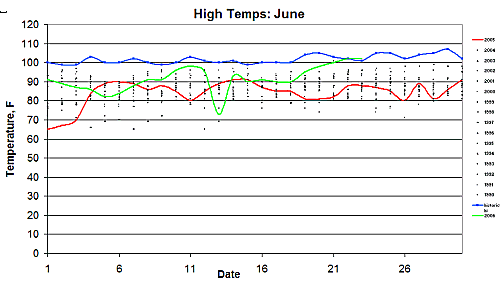
Just to celebrate our misery and impending redemption, here's what June has looked like so far for the Athens area. Green line is 2006, red line is 2005. The 108-year historical high is in blue. The black dots are the high temperatures for each June day since 1990.

0 Comments:

Post a Comment

<< Home