Wolfskin District
We here at WVFD have had a number of reasons for wanting to get a good idea of the extent of our community. We're working right now on a map that defines the boundaries in a way that will assist us in several ways, not the least of which is a nice wall-sized map of the area. We want a county-wide map, of course, but a county is way too big for our primary responsibility area. Within Oglethorpe County areas are mapped out by 911 Emergency definitions, watershed definitions, Fire Districts, insurance maps, all kinds. Here I suggest that at least some, if not many, of those definitions can be traced to a map drawn up more than two hundred years ago.
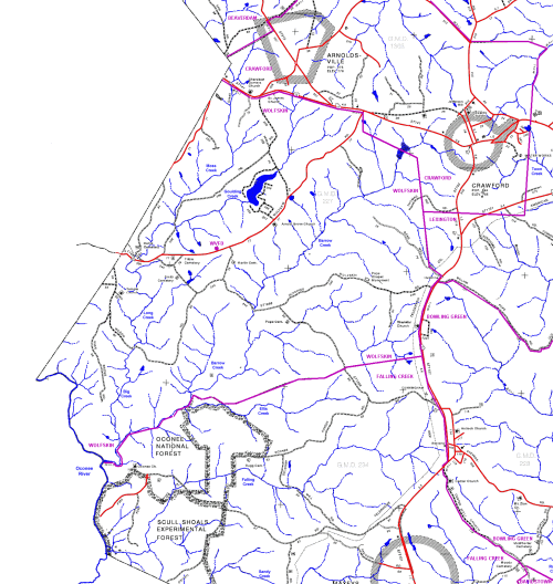
The maps that I present here are from one I had located from this source for a finely detailed map of Oglethorpe County. I spent quite a number of hours downloading sections and pasting them together and coloring in roads and creeks.
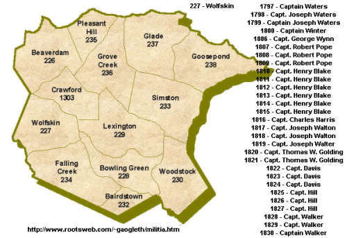
The other day I was idly googling for the origin of the name "Goulding" as in Goulding Creek, and ran across this site which details the history of militia districts in Oglethorpe County. It appears that Wolfskin District is mentioned as early as 1797, formed for the purpose of defense during post-Revolution colonial times.
(That site, by the way, is an extremely interesting source for information about Oglethorpe County history, including scans of maps from the 1800s onward, prominent families in Oglethorpe County, and essays on towns. It is part of the USGenWeb Project, and you might just find your county listed there.)

The other districts on this map are also still in evidence - Beaverdam, Crawford, Lexington, Glade, Goosepond - all retain their names. Falling Creek District doesn't ring a bell for me, but might now be referred to as the District under Maxeys's jurisdiction.
The reason that this is of interest is that the outlines of the militia districts appear to have been conscripted for present day fire protection responsibilities. That is, Wolfskin Volunteer Fire Department has primary responsibility for the region fully outlined in purple in this section of the detailed, colorized map:

(I have linked the above, admittedly fuzzy map to a much better, larger 373KB map for local readers who might want to print it out. And I also have a much, much larger 1.8MB map of the entire county, rather than just the above section, but email me if you want it.)
This doesn't tell the whole story. Arnoldsville VFD to our north would appear to be part of Crawford Militia District, and yet it has its own fire jurisdiction today, so some changes have been made. The above map should not be taken as accurate even for WVFD. It simply appears that at least some present-day fire jurisdictions have derived from late 18th century militia districts. But how accurate is it?
Present day fire jurisdictions are multiple and overlapping - there are Primary Responsibility districts, which the purple above purports to outline, and then there are overlapping lines that map out Automatic Aid from neighboring districts. Automatic Aid refers to structure fires, considered to be rather important. If WVFD is called out for a structure fire in its Primary jurisdiction, then our Automatic Aid friends, Arnoldsville to the north, Crawford to the northeast, and Maxeys to the south, will be automatically paged too. (Each VFD has a number - WVFD is F4, and each member has his or her own number that starts with that one - I am 411, and Glenn is 418. Maxeys is F3, Crawford is F6, Arnoldsville is F11. And so on. Too much information, I know, but this is documentation, right?)
As it turns out, all those assignments are made by 911, with input from the fire chiefs in the county. It may surprise some, but we didn't have 911 here in Oglethorpe County until about ten years ago - we even had to vote in a referendum to get it. But now that we have it, all maps are standardized to that. The nice thing is that 911 will give us, if we ask nice, maps of the area along with details like road names and address numbers.
Glenn has located a map of those assignments and is in the process along with Bill, one of our civilian WVFD Board members, of applying that so that we eventually have a full-featured wall-sized map. But we can at least test the "militia district hypothesis" here.
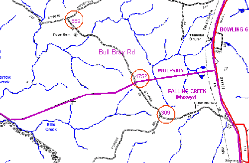
Here is a blowup of the area to our southeast, along Bull Bray Road.

The jagged horizontal purple line is the demarcation between "Falling Creek" (now referred to as Maxeys) and Wolfskin, according to the late 18th century militia district lines. I've noted three addresses along this road and circled them in red. 911 claims that Wolfskin has jurisdiction from Box 476 to Box 869, and Maxeys has jurisdiction from Box 0 to Box 475B. It really looks to me like the militia district lines successfully predict the 911 assignments, and that the county fire chiefs used those lines as a guide to drawing up primary responsibility areas a decade ago.
Now you might ask, "who cares, Wayne?" Well, here's something: we ask for donations now and then, and we don't want to go outside our area and trod on the feet of our adjacent VFDs. Here's something else, which complicates things a bit: fire insurance is graded in Classes, and we are at Class 9 right now, which means, well, not very good. We want to be Class 8B, which will save all the residents of the Wolfskin District a fair amount of money. So we need to know who would be promised that Class change. But the Insurance Service Organization that makes those assignments doesn't necessarily follow the 911/militia maps, and we have to determine who we can promise and who we can't. That's the next step: How does the ISO divvy things up?
Oh yes, Goulding Creek. Did I ever find the origin of the name "Goulding"? No, but it is interesting that one of the militia captains (1820-1821) is Thomas W. Golding. None of the maps at the USGenWeb site is detailed enough, except possibly the 1894 map, to show Goulding Creek, and that one is 70 years in Captain Golding's future. Miss Flossie Smith might have something to say about this, but it's a little hard to get her book!
--Wayne


0 Comments:
Post a Comment
<< Home