
How Much Rain?
I posted a version of this elsewhere, but it struck me that this could be a very important thing for fire departments, especially volunteer fire departments, to know. So I'm tailoring it for this blog to let others know what's available.
I was recently alerted to CoCoRaHS, the Community Collaborative Rain, Hail, and Snow Network. I took a look at it and thought about it for a day and then I registered. I have a considerable interest in weather, I love to see maps, I love the idea of citizen participation, and I love seeing Oglethorpe County maps. So.
Before I say anything else, let me say this: get over to the CoCoRaHS page, and register. Better yet, get your kids to do it, if you have kids. Nothing could be easier, nor the instant gratification so great. If you have an interest in the weather, and who does not?, you can add to a daily database that provides unique and valuable information. If you can read a rain gauge, remember to read it every morning by 7am, have enough access to the internets to log on and put in one number and hit submit, then that's it! It occupies about 5 minutes of your time, or better yet (again), your kids' time. CoCoRaHS would like everyone to use the same rain gauge, so there is that investment (I ordered mine yesterday, even though I have a good one), and they would like everyone to have participated in at least an online training session.
Now not all states are yet a part of it, but many that are not, are coming online in 2008 - check the home page for CoCoRaHS for the listing. Georgia just came online May 1, due to the efforts of a few interested folks. California goes online in October, it looks like. HAHA - Georgia beat California, neener neener.
I took a few screenshots because I think it's pretty impressive. As I said, there's instant gratification, and your results are updated fairly instantly onto the maps. For firefighters, knowing the rainfall in parts of the county can be pretty important. I know how much rain fell yesterday here in my little spot at Wolfskin, but I have no idea how much fell near Vesta, or Philomath, and as we all know, rainfall can be different even a few miles away, and Oglethorpe County is a BIG county. Well, this tells you that, provided there's someone to report.
And I can enjoy refreshing the Oglethorpe County map (there are *12* active participants in Oglethorpe - imagine that!) during the course of the early morning to see my fellows gradually adding their data along with mine. The power of the internets, used the way it should be!
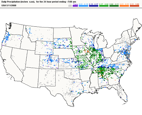
Here's the US map on May 11, the Mother's Day storm system, for rain that fell from 7AM May 10 to 7AM May 11. You can pretty much tell the states that don't participate yet - Washington, California, Minnesota, Arkansas (and isn't that a pity, considering), but many of those are coming online soon. The gray dots are reports of no rain, and those are extremely important. ALWAYS enter the zero for no rainfall - that negative evidence is just as good as any rain at all, even better.
Just look at Oregon: you can see where the rainshadow cast by the mountains is just by viewing the transition from blue dots to gray ones.
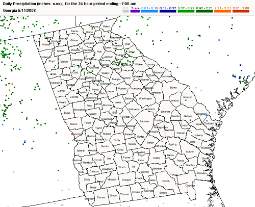
Here's the map of Georgia on the same day, with portions of surrounding states. Unfortunately a lot of folks who are registered didn't add their data if there was no rainfall. But they should have! And you can see that there are empty counties - Georgia needs a lot more participants, particularly if you live in a rural area. CoCoRaHS ultimately would like to see active participants every few square miles, and especially in rural areas. But not bad, really, considering that Georgia has only been online for less than three weeks.
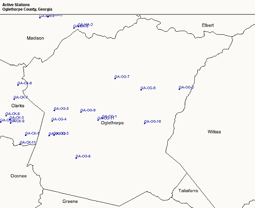
Here's what you see when you look at the station map for Oglethorpe County. I'm down there at near the southwestern boundary with Clarke County. Notice that my station, GA-OG-12, is right next to GA-OG-3, the labels overlap. That's my neighbor up the street. But those data are not redundant, because even a mile away rainfalls can be different, as everyone knows. And that's another thing - yes of course there are professional weather stations, but they're so far and few between, nothing like this density.
However, you can see that parts of the county are not represented. We need some Beaverdam folks, some Philomath firefighters, maybe Vesta, Salem, Glade, and Maxeys too, to add their data.
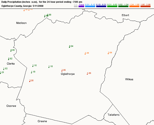
And so on May 11, nine of the twelve Oglethorpe County participants gave climatologists and other interested parties these data. I'm the 2.00 inches of rain, but just north of me two folks only got half that, whereas Lexington got slightly more than that.
It's that degree of resolution that makes this so valuable, something that cannot be achieved professionally.
Another benefit: yesterday's email exchanges with the Oglethorpe County Coordinator, as well as with the Georgia Region 1 Coordinator, introduced me to a couple of great folks whose interests overlap considerably with mine, and not just in the arena of measuring rainfall.
I see the possibility of uploading this county map on a daily basis, to inform everyone of the previous day's rainfall. Much of the time (as we know) we'll all know we're dry and should be careful. But rain falls the way it wants to, and some parts of the county may be dry and some not. Wouldn't it be good to know?
--Wayne
posted by Wayne Hughes @ 7:54 AM
0 comments
![]()

