A Nice Day for a Burn
I mentioned on March 30 that three of us were busy building fire breaks around a 3/4 acre section of the fire station property, back of the station. We completed these on Friday April 12, with plans to conduct a prescribed burn on Saturday.
We didn't have a large group, but fortunately our experienced wildlife biologist across the creek joined us, along with his wife, our former chief. I called the Lexington Georgia Forestry Commission office at 8am and was given permit #306.
I had been a little concerned about whether GFC would be giving out prescribed burn permits on Saturday. The weather was lovely, but from a burn point of view had deteriorated somewhat. That day's point forecast predicted higher temperatures than previously expected (though still in the low 80s) and humidities dipping toward 25% and below in the late afternoon (25% is usually the trigger for fire weather). The winds were still predicted to be very calm, and perhaps that was the ameliorating factor.
At any rate, we were given the permit, and we got going with a plan I'd jotted down. I've added to it with some postburn data. Now, although all of us have participated in some wildland fire control, and several of us in prescribed burns, this was the first time I'd planned and set up for a burn.
I called 911 to alert them, although they're able to access GFC's website to discover permitted burns when concerned folks call in. And we put our large sign out front, alerting passersby that we were conducting a "control burn" (like "boil peanuts") and that they should not call 911. Those were nice touches that made our 911 sheriff's office happy.
The plan below shows the rectangular burn area just north of the station.
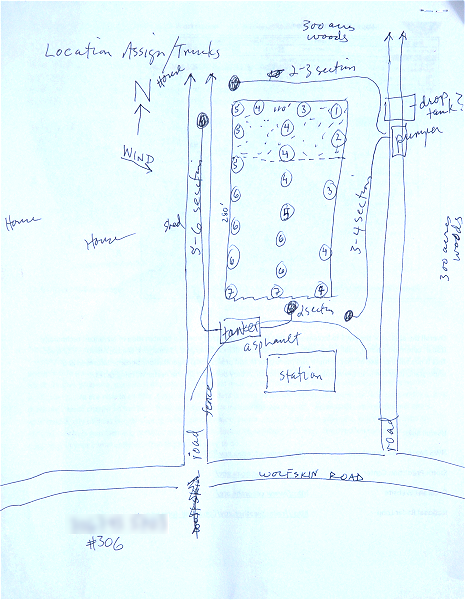 | North is up, and the wind was primarily coming from the northwest. I had wanted that in order to blow smoke into the 300 acres of uninhabited land to the east, and not back to the few houses on the left and across Wolfskin Road. |
There are two long dirt roads that run parallel to the long dimension of the property. We positioned the pumper most of the way down the right-hand road, and the tanker in back of the station. We ran two lengths of hose from each engine to protect all sides of the property (and the properties on the other side of the access roads!).
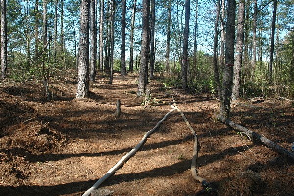
Here's the setup before we began the burn. This is one of the two hoses that ran 150 feet (three lengths) from the pumper on the east access road.
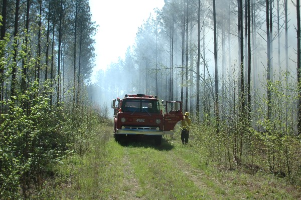
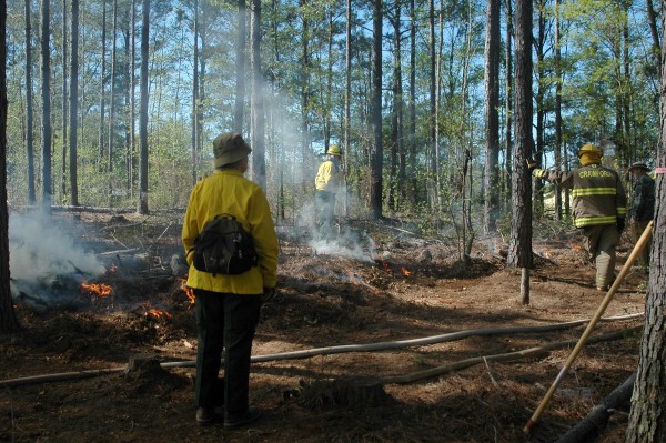
Here's the worthy pumper on the east access road. Glenn was the pump operator here. We're facing south, so the above hoses run right into the property, and the second set run unseen 300 feet (six lengths) south behind the pumper. The photo was obviously taken after the burn started, but as you can see the smoke is blowing in the desired direction, away from houses and toward unimproved land.
We had a similar arrangement with the tanker on the other side of the property.
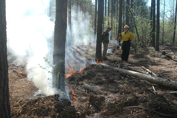
So we started our burn with a drip torch at the northeast corner, the most downwind part of the property, just inside the fire break. On the plan above, this is marked by a circled "1". This was also inside the 1/3 or so of the property that had thinned pines on it. We really needed to get this area burned today, since burning under pines would be banned for the season in a few days.
We watched that begin to slowly spread, and then started spots down the east break, in the area marked "2". This set up a "back burn," which is started at and burns at the break and slowly upwind against the wind. With this, you're extending the fire break safely, and making a much wider burned area that fire cannot easily cross.
That's Charleen, there, who worked with Glenn and me in making the fire breaks over the last two or three weeks. And our wildlife biologist advisor.
After a bit of that, we further extended the back burn southward down the fire break, always burning backward into the wind. And we started a parallel burn toward the back burned portion. All marked "3".
That's Phyllis in the foreground, our former fire chief. She's standing in the fire break, with a hose running in front of her.
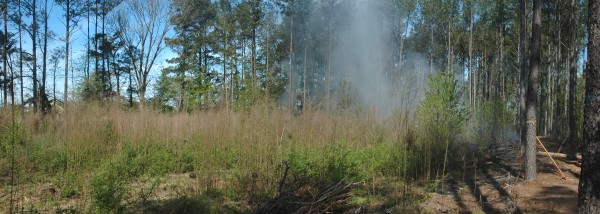
At this point, we had a nice line of fire down the break, burning backwards into the wind. I took this panorama (click for larger image on new page) of three or four single photos. As you can see, the wind reversed direction on us for a few minutes - it should have been blowing to the right. It was no problem, even if it had been sustained, as we had already begun the spot ("4") and headwind ("5") burns in the center and left (west) side of the property.
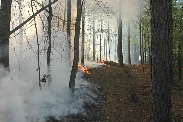
One of my favorite single shots, this one shows exactly one of those headwind burns on the left (west) side of the property. This time the wind is cooperating with us. The unburned strip on the right is our fire break that we worked so hard on. Now it's a very nice path that circumnavigates the property.
Here are a few panoramas of Saturday's festivities. I spend a lot of time on these, and have figured out a *nearly* foolproof method of getting evenly lit photos. The rapidly shifting fire and smoke taxed even that method, and there are a couple of flaws in the stitching.
Clicking on each opens a large image in a new page.
These two are my favorites, especially the top one, below, taken looking approximately north, about midway through the burn. On the left, you can see the fire break, with Charleen monitoring that portion. The fire is blowing toward the very first, already burned fire breaks.

And below is the result, a few days later, more or less taken from the same angle and direction. The unburned branches and small felled trees tell you that our burn was not too hot, because it didn't burn freshly cut vegetation. However it did burn branches and trees that had fallen or been felled in the previous two years.

Glenn and I especially will be interested in seeing whether seldom seen fire resistant plants come up in the next year or so.
This one is actually the last photo of the day. Unseen to the right is the station, and the tanker was our protective resource here. A hoseline runs toward us and down the access road to protect that area. We're all just relaxing, more or less, since the burn is just about done ("7" on the map at the top) - Glenn would prefer a chaise lounge. Apparently we slowed down quite a bit of traffic on Wolfskin Road, as drivers paused in curiosity.

So in the end it was a burn that worked just about perfectly. Our preparations were adequate to keep us from getting anxious at wind direction changes, and the day's weather was just about perfect for the event. No mistakes were made, and our safety features were way beyond what were needed. Still, I really was scared to death something would go wrong, but that's just me.
The next day, Sunday, would have been terrible. The wind would be coming from the east, which around here is a promise for gusts and wind direction changes. And it would be lightly raining by late morning or early afternoon.
Why did we want to do this? Partly it was a training exercise that I thought really needed to be done. But mostly the larger part of the property had been clear cut, with a lot of debris left on the ground. After two years a good bit of blackberries, sweetgums, and other primary succession growth had come up. It seemed like, and was, a good way to accomplish two things at once.
In the end, we want to put a new fire station on this property. The pathway to that goal is not clear, but that's no reason not to use the property as training every 2-3 years for prescribed burns. The result will be an interesting and beautiful grassy backyard, with likely fire-selected wildflowers.


